
Whether you’re planning a weekend hike, deciding what to wear to work or preparing your home for severe storms, the weather forecast is essential. You might instinctively grab your smartphone and check an app for an instant weather update.
But how many times have you looked at your app, only to step outside and see the sky painting a different picture than what’s on your screen?
As a meteorologist who operates a weather station network in Wisconsin, I’ve heard many of the same cliches time and again: “The weatherman is always wrong!” “Just wait five minutes and the weather will be different!”
Before you blame the local forecasters, let’s talk about where the data in your weather app comes from, and why it might not always show what you expect. It’s why my colleagues and I are working to bring forecast data closer to home.
The nuts and bolts of weather forecasting
Earth is huge. It has a diameter of 7,926 miles (12,756 kilometers) at the equator and has 62 miles (100 kilometers) of atmosphere overhead.
If you want a perfect weather forecast, you will have to precisely measure every molecule of the atmosphere, land and water, and perfectly predict how they will interact with each other for the next minute, day or week. This is, of course, physically impossible.
Instead, scientists run computer models. These models take the observations we do have and simulate the weather on a large scale to a remarkable degree of accuracy. In fact, storm track forecasts from the National Hurricane Center were among its best ever in 2025, and forecasts using machine learning are starting to improve those forecasts even further.
These models are hungry for data. Supercomputers ingest measurements from satellites, weather balloons, Doppler radar, lightning detection networks, buoys, surface weather stations and other measurement platforms to solve the equations that provide weather predictions.
When you open your phone, your weather app isn’t doing the meteorology – it’s just showing the output of the model’s calculations. Even though they generally aren’t tailored by a local meteorologist, these short-term forecasts are usually pretty good. But they could be better.
All weather is local
You’ve probably seen it before: It’s raining on one side of the street and not on the other. You flip on the news to see the nearest airport received an inch of rain, but your garden is dry.
There are more than 2,500 airports in the United States with weather stations, which is where much of the weather data shared on TV and online is collected. But for many people, the closest airport is more than 20 miles (32 kilometers) away. This is especially true in rural areas.
Chris Vagasky
Because of the chaotic nature of weather, the only way to truly know what’s happening in your yard is to measure the weather in your yard. But not everyone is interested in installing a rain gauge or personal weather station.
Filling the gaps
To bridge this gap, many states and universities have established local weather station networks called mesonets – short for mesoscale networks, meaning intermediate scale. These weather stations are installed in locations to ensure everyone in the state is within 20 miles of the nearest station.
Nationally, there are nearly 3,000 mesonet stations installed in 38 states, with more networks planned.
Like the weather stations at airports, mesonets measure things like air temperature and relative humidity, air pressure, rainfall or melted snow, and wind speed and direction – often every five minutes.
Many mesonets collect additional data such as soil moisture levels to help farmers. Some even have camera images updated every five minutes to show current weather conditions. Mesonet data is then shared through websites or direct data transmission so that the public, weather forecasters and researchers can easily access it.
I lead the team at Wisconet, a new mesonet that just finished installing 78 weather stations across Wisconsin. Our stations are installed on 10-foot-tall (3-meter) tripods in open areas near orchards and cranberry marshes, farms and airfields, schools and other educational centers, and on city, state and federally owned lands.
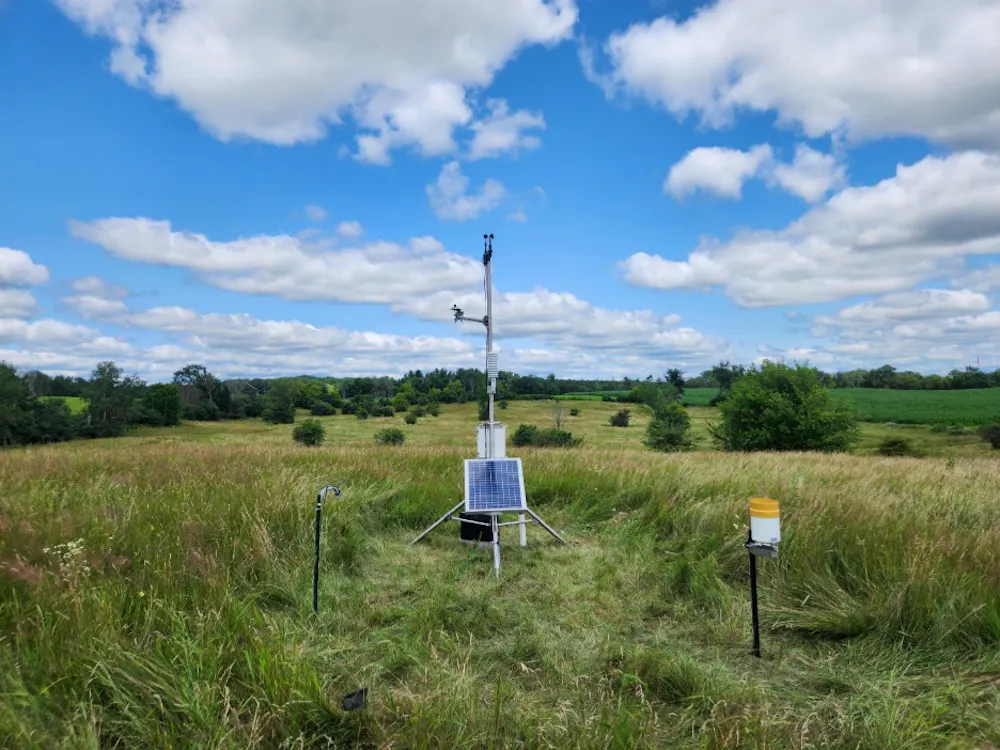
Caitlin Wienkes, Wisconet
These added weather stations are already proving useful. On Aug. 18, 2025, slow-moving thunderstorms moved over a Wisconet station, with more than 3 inches of rain falling in just a couple of hours. The National Weather Service was able to issue a flash flood warning for the area because of the data provided by that station.
In addition to providing a near-real-time snapshot of the local weather, mesonets help farmers decide when to run irrigation systems, spray pesticides or plant crops. They also help provide better weather warnings, particularly when tornadoes and other storms intensify over small areas that farther-away weather stations would miss.
A nationwide network of networks
Because of the immense value of high-frequency weather and soil measurements, the National Oceanic and Atmospheric Administration leads a National Mesonet Program. The program collects weather data from public, private and academic sources, validates the quality of the data, and ensures it flows to users, including the National Weather Service. National Weather Service forecasters use that data to make more timely and accurate severe weather warnings.
Congress is considering expanding that program, with legislation proposed in the House and the Senate. The bills aim to authorize $50 million to $70 million annually to the National Mesonet Program between 2026 and 2030 to improve and expand mesonets across the country. An expansion would mean more weather stations and new capabilities, like real-time snowfall, fire weather and air quality measurements, closer to the people who rely on them.
So the next time you check your smartphone and grumble because the app doesn’t match the weather in your backyard, remember that all weather is local. If you don’t have a nearby mesonet station, the nearest measurements may be many miles away.